


Columbus Twp B Precinct, Platte County, Nebraska
About
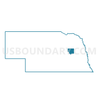
Outline

Summary
| Unique Area Identifier | 613714 |
| Name | Columbus Twp B Precinct |
| County | Platte County |
| State | Nebraska |
| Area (square miles) | 27.26 |
| Land Area (square miles) | 25.10 |
| Water Area (square miles) | 2.16 |
| % of Land Area | 92.08 |
| % of Water Area | 7.92 |
| Latitude of the Internal Point | 41.44139980 |
| Longtitude of the Internal Point | -97.40907150 |
Maps


Graphs
Select a template below for downloading or customizing gragh for Columbus Twp B Precinct, Platte County, Nebraska


Neighbors
Neighoring Voting District (by Name) Neighboring Voting District on the Map
- Alexis Precinct, Butler County, NE
- Bismark Precinct, Platte County, NE
- Butler/Loup Precinct, Platte County, NE
- Columbus Twp A Precinct, Platte County, NE
- Columbus Ward 1D, Platte County, NE
- Columbus Ward 2A, Platte County, NE
- Columbus Ward 2B, Platte County, NE
- Columbus Ward 2C, Platte County, NE
- Columbus Ward 2D, Platte County, NE
- Columbus Ward 3A, Platte County, NE
- Columbus Ward 3B, Platte County, NE
- Columbus Ward 3C, Platte County, NE
- Columbus Ward 3D, Platte County, NE
- Columbus Ward 4C, Platte County, NE
- Columbus Ward 4D, Platte County, NE
- Lost Creek/Burrows Precinct, Platte County, NE
- North Osceola Precinct, Polk County, NE
- Oconee/Monroe Precinct, Platte County, NE
- Shell Creek Precinct, Platte County, NE
Top 10 Neighboring County Subdivision (by Population) Neighboring County Subdivision on the Map
- Columbus city, Platte County, NE (22,111)
- Columbus township, Platte County, NE (3,160)
- North Osceola precinct, Polk County, NE (987)
- Shell Creek township, Platte County, NE (867)
- Alexis township, Butler County, NE (674)
- Butler township, Platte County, NE (604)
- Oconee township, Platte County, NE (523)
- Lost Creek township, Platte County, NE (517)
- Bismark township, Platte County, NE (462)
- Loup township, Platte County, NE (139)
Top 10 Neighboring Place (by Population) Neighboring Place on the Map
Top 10 Neighboring Unified School District (by Population) Neighboring Unified School District on the Map
- Columbus Public Schools, NE (23,264)
- Lakeview Community Schools, NE (5,188)
- Shelby Public Schools, NE (1,510)
Top 10 Neighboring State Legislative District Upper Chamber (by Population) Neighboring State Legislative District Upper Chamber on the Map
- State Senate District 23, NE (40,859)
- State Senate District 22, NE (35,193)
- State Senate District 34, NE (35,089)
Top 10 Neighboring 111th Congressional District (by Population) Neighboring 111th Congressional District on the Map
Top 10 Neighboring Census Tract (by Population) Neighboring Census Tract on the Map
- Census Tract 9653, Platte County, NE (7,479)
- Census Tract 9655, Platte County, NE (5,427)
- Census Tract 9654, Platte County, NE (4,806)
- Census Tract 9676, Butler County, NE (3,327)
- Census Tract 9652.98, Platte County, NE (3,208)
- Census Tract 9657, Platte County, NE (3,188)
- Census Tract 9600, Polk County, NE (2,167)